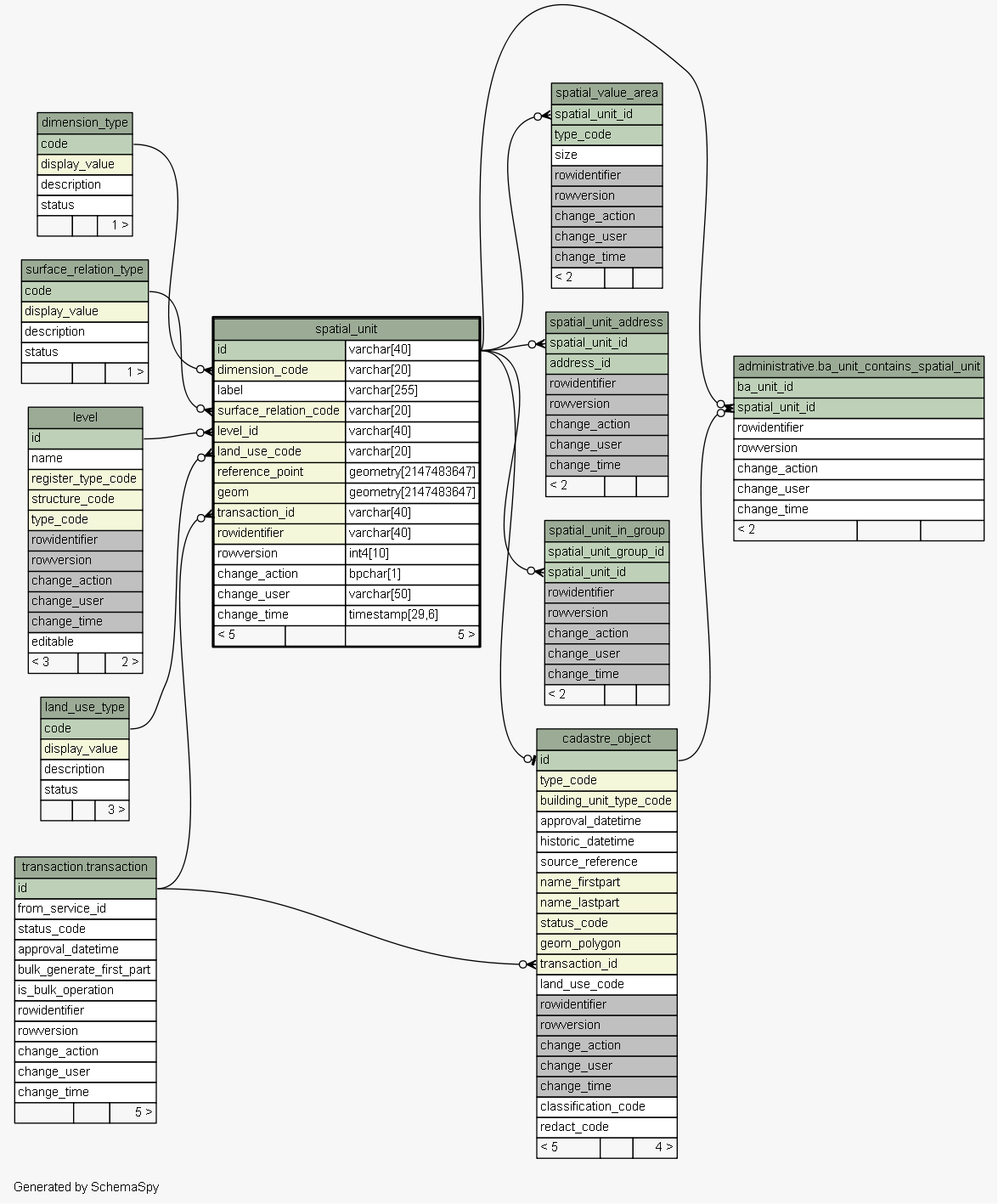
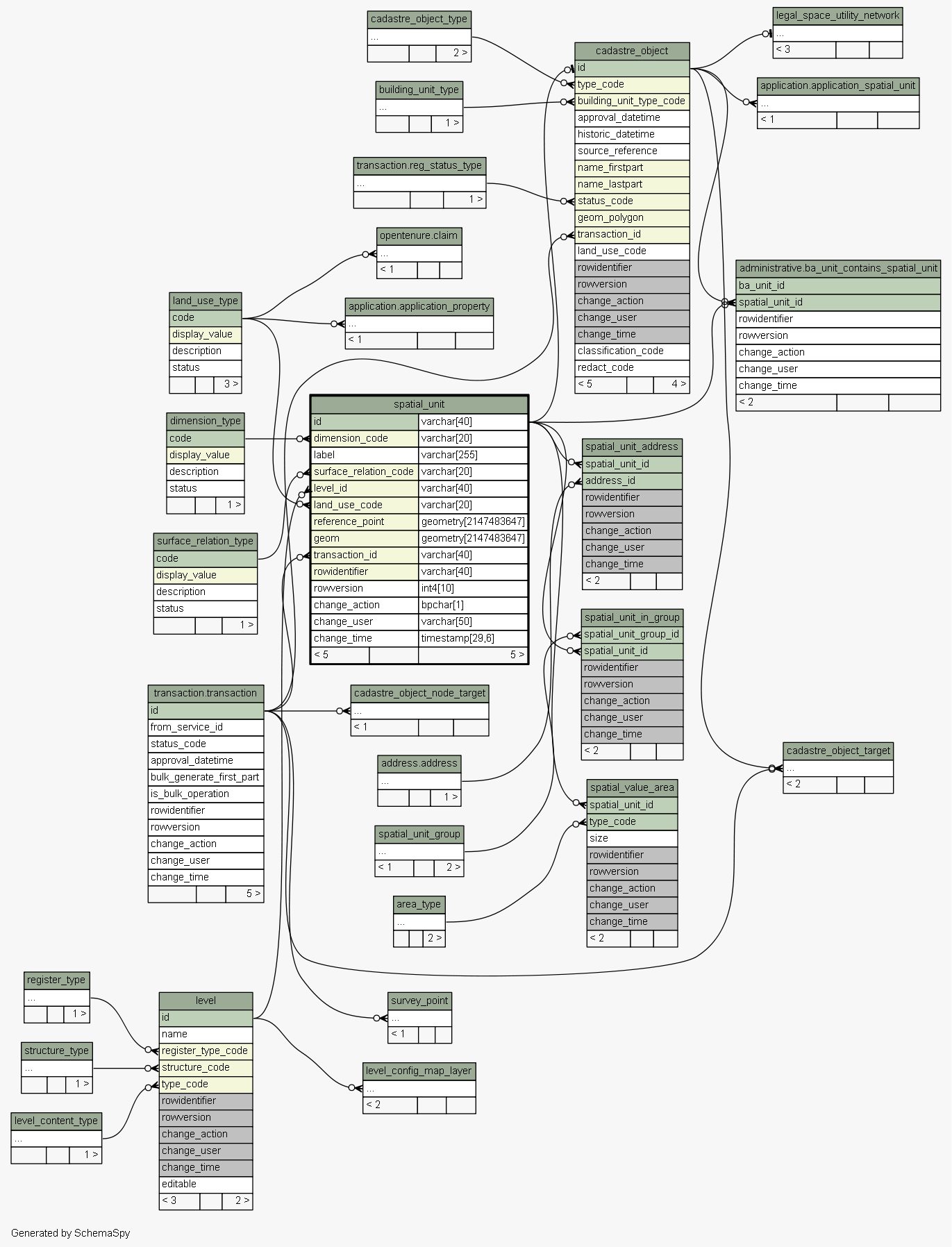
| Table sola.cadastre.spatial_unit Single area (or multiple areas) of land, water or a single volume (or multiple volumes) of space. Implementation of the LADM LA_SpatialUnit class. Can be used by SOLA to represent geographic features such as place names and roading centrelines that are not considered as cadastre objects. Tags: LADM Reference Object, Change History
|
Generated by SchemaSpy |
| |||||||||||||||||||||||||||||||||||||||||||||||||||||||||||||||||||||||||||||||||||||||||||||||||||||||||||||||||||||||||||||||||||||||||||||||||||||||||||
Analyzed at Tue May 31 09:57 NZST 2016 | |||||||||||||||||||||||||||||||||||||||||||||||||||||||||||||||||||||||||||||||||||||||||||||||||||||||||||||||||||||||||||||||||||||||||||||||||||||||||||
Indexes:
| Column(s) | Type | Sort | Constraint Name |
|---|---|---|---|
| id | Primary key | Asc | spatial_unit_pkey |
| dimension_code | Performance | Asc | spatial_unit_dimension_code_fk55_ind |
| geom | Performance | Asc | spatial_unit_index_on_geom |
| reference_point | Performance | Asc | spatial_unit_index_on_reference_point |
| rowidentifier | Performance | Asc | spatial_unit_index_on_rowidentifier |
| land_use_code | Performance | Asc | spatial_unit_land_use_code_fk66_ind |
| level_id | Performance | Asc | spatial_unit_level_id_fk57_ind |
| surface_relation_code | Performance | Asc | spatial_unit_surface_relation_code_fk56_ind |
| transaction_id | Performance | Asc | spatial_unit_transaction_id_fk67_ind |
|
Excluded from diagram's relationships: cadastre_object.rowidentifier spatial_unit_group.change_action spatial_value_area.rowidentifier level.change_time cadastre_object_node_target.rowversion spatial_unit_address.change_action survey_point.rowidentifier spatial_unit_address.change_user survey_point.change_time spatial_unit_group.rowversion spatial_value_area.change_time spatial_unit_in_group.change_action level.change_user legal_space_utility_network.change_user spatial_unit_in_group.rowidentifier cadastre_object_node_target.rowidentifier cadastre_object_target.change_time legal_space_utility_network.change_time cadastre_object.change_user legal_space_utility_network.rowversion cadastre_object_node_target.change_time spatial_unit_in_group.rowversion survey_point.change_action cadastre_object_node_target.change_user cadastre_object.change_time spatial_unit_group.rowidentifier survey_point.change_user spatial_unit_in_group.change_time level.rowversion level.change_action cadastre_object.change_action survey_point.rowversion legal_space_utility_network.change_action spatial_unit_group.change_user spatial_value_area.change_action cadastre_object_target.change_user spatial_unit_group.change_time spatial_unit_address.change_time cadastre_object_target.rowversion spatial_value_area.rowversion spatial_value_area.change_user cadastre_object_target.rowidentifier legal_space_utility_network.rowidentifier cadastre_object.rowversion spatial_unit_in_group.change_user cadastre_object_target.change_action level.rowidentifier spatial_unit_address.rowversion spatial_unit_address.rowidentifier cadastre_object_node_target.change_action