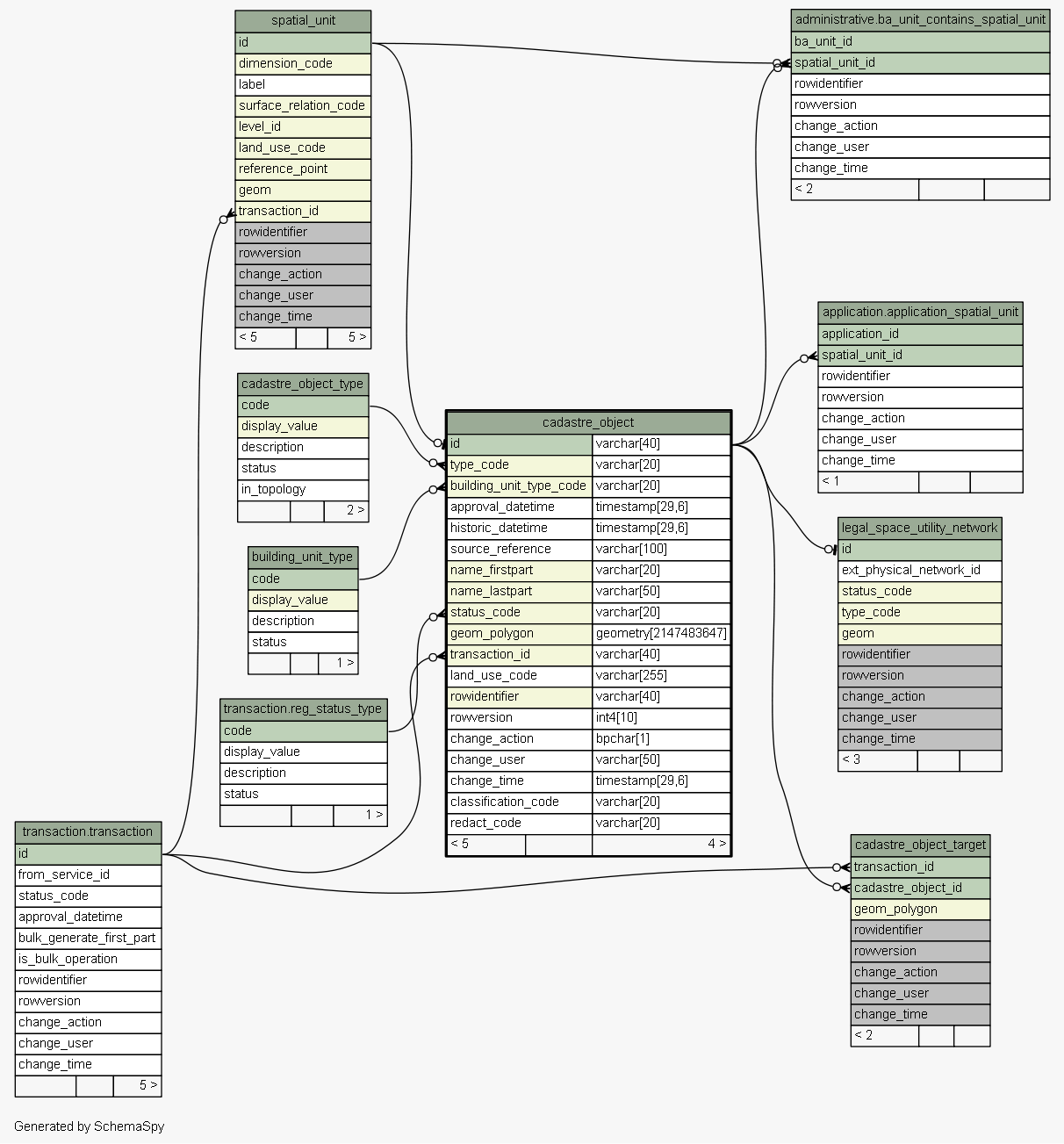
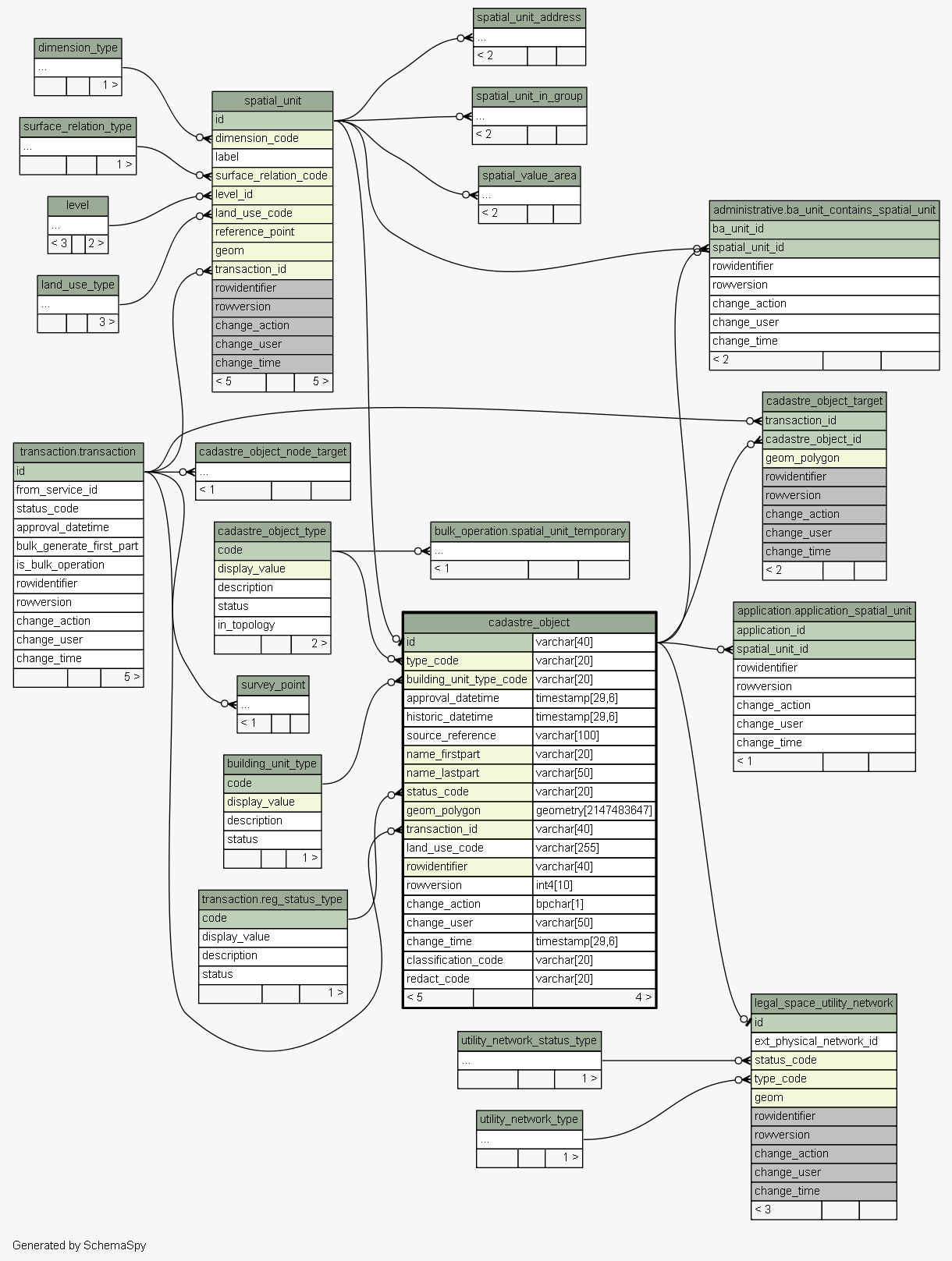
| Table sola.cadastre.cadastre_object Specialization of Spatial Unit that represents primary cadastral features such as parcels. Parcels captured in SOLA should have a spatial definition that illustrates the shape and geographic location of the parcel although this is not a mandatory requirement. Parcels without a spatial definition may be referred to as aspatial or textual parcels. Tags: FLOSS SOLA Extension, Change History
|
Generated by SchemaSpy |
| ||||||||||||||||||||||||||||||||||||||||||||||||||||||||||||||||||||||||||||||||||||||||||||||||||||||||||||||||||||||||||||||||||||||||||||||||||||||||||||||||||||||||||||||||||||||||||||||||||||||
Analyzed at Tue May 31 09:57 NZST 2016 | ||||||||||||||||||||||||||||||||||||||||||||||||||||||||||||||||||||||||||||||||||||||||||||||||||||||||||||||||||||||||||||||||||||||||||||||||||||||||||||||||||||||||||||||||||||||||||||||||||||||
Indexes:
| Column(s) | Type | Sort | Constraint Name |
|---|---|---|---|
| id | Primary key | Asc | cadastre_object_pkey |
| building_unit_type_code | Performance | Asc | cadastre_object_building_unit_type_code_fk64_ind |
| id | Performance | Asc | cadastre_object_id_fk61_ind |
| geom_polygon | Performance | Asc | cadastre_object_index_on_geom_polygon |
| rowidentifier | Performance | Asc | cadastre_object_index_on_rowidentifier |
| name_firstpart + name_lastpart | Must be unique | Asc/Asc | cadastre_object_name |
| status_code | Performance | Asc | cadastre_object_status_code_fk63_ind |
| transaction_id | Performance | Asc | cadastre_object_transaction_id_fk65_ind |
| type_code | Performance | Asc | cadastre_object_type_code_fk62_ind |
|
Excluded from diagram's relationships: spatial_unit_group.change_action spatial_value_area.rowidentifier level.change_time cadastre_object_node_target.rowversion spatial_unit_address.change_action survey_point.rowidentifier spatial_unit_address.change_user survey_point.change_time spatial_unit_group.rowversion spatial_value_area.change_time spatial_unit_in_group.change_action level.change_user legal_space_utility_network.change_user spatial_unit_in_group.rowidentifier cadastre_object_node_target.rowidentifier cadastre_object_target.change_time legal_space_utility_network.change_time spatial_unit.rowidentifier legal_space_utility_network.rowversion cadastre_object_node_target.change_time spatial_unit_in_group.rowversion survey_point.change_action cadastre_object_node_target.change_user spatial_unit.change_user spatial_unit_group.rowidentifier survey_point.change_user spatial_unit_in_group.change_time spatial_unit.change_time level.rowversion level.change_action survey_point.rowversion legal_space_utility_network.change_action spatial_unit_group.change_user spatial_value_area.change_action spatial_unit.change_action cadastre_object_target.change_user spatial_unit_group.change_time spatial_unit_address.change_time cadastre_object_target.rowversion spatial_value_area.rowversion spatial_value_area.change_user cadastre_object_target.rowidentifier spatial_unit.rowversion legal_space_utility_network.rowidentifier spatial_unit_in_group.change_user cadastre_object_target.change_action level.rowidentifier spatial_unit_address.rowversion spatial_unit_address.rowidentifier cadastre_object_node_target.change_action